Generate an interactive event map to increase customer engagement and help event-goers orient themselves. This mobile map enables the public to find different services products and locations such as stages toilets beer charging station information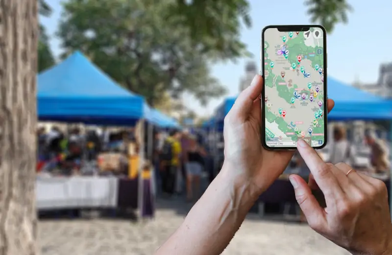 desk first aid vegan vegetarian and locally produced food etc..
The resulting public event map can be integrated to the event's web site and access from desktops prior to the event, or from phones while at the event. It can also be included as an external link in most festival app software , although another option is to altogether replace your often expensive and cumbersome apps with EventMapStudio.
The Value:
- Automatically generated from your event layout. No external fees. No waiting.
- ONE map, visible on your web site or on the public's phones. No discrepancy. No multiple updates.
- Dynamic, geo-enabled. Enables the public to explore.
- Vendor placement/advertising creates an additional revenue source for your event.
Possibility to automatically generate a page listing all the sustainable options available at your event, and describing all your sustainability work that might otherwise go unnoticed.
Click here to see a real-life example of one of our clients leveraging this capability, including the vendor placement and sustainability education/promotion.
Any changes even last minute ones in your plans instantly updates the map your eventgoers see. No more waiting (and paying) on a third-party vendor to build or update an event map that will be outdated the minute you make any change on your master map.
As the map designer you decide which items are visible on the mobile/public map. You can also include a graphical overlay to make your map fancier.
2 simple steps:
- In the Map Display section of your event definition check the Visible to the general Public checkbox
- For each item you want visible on the public map select the item and either select Export Item from the pop-up menu (right click) OR go to the Advanced Options section of the Object Inspector palette and click on Visible on export map.
Remember an item can only be visible on the eventgoer map if it has properties that are exportable. Except for certain types of objects (toilets stages entrances public transportation parking) the object itself is not exported only its properties are. For example a tent will not be visible on the public map only its properties such as lockers or vegan food will.
An event-goer map that shows you serve vegan vegetarian and locally produced food that shows you sell eco-responsible merchandise that includes public transit options bicycle carpool and electric car parking that points out water bottle refill stations and that shows car-sharing pickup & drop-off areas is the best way to promote sustainability and show the public you care as much as they do.