Planning an event means juggling many different audiences — attendees trying to find the stage, vendors needing to know their location, staff managing backstage logistics. An interactive event map solves all of this from a single source of truth. With EventMapStudio, you create one master map that is automatically displayed differently depending on who is looking at it — a public-facing interactive festival map for attendees on their phone, a filtered map for your tent vendor, a complete backstage map for your staff. Any last minute change you make is instantly reflected across all views. Here is how it works..or just experience it yourself with a free trial.
THE map
The first interactive festival map in EventMapStudio is a map event producers can produce to layout and manage their event. This complete map includes everything, that is it includes both the public facing items such as stages, or portalets and the backstage items such as staff parking, or artist trailers. It is to scale and fits the requirements of many regulatory requirements to produce a map. It is the definitive map of the event and includes everything that needs to be there. The uniqueness of this map is that it is targeted at the people producing the event, unlike many other maps usually targeted at people attending the event.
Filtered event maps
From this first map, one can filter the items by types. EventMapstudio will let you generate automatically a map with only the tents, or only the stages. There are many more categories that can be used to filter items, and these categories can be combined. You could for example produce a map with all the entrances and the public transportation around them. These filters are useful to make the event map less overwhelming, and to share information with certain stakeholders. For example you could decide to share a tent-only map with your tent vendor, or a restroom-only map for the person delivering the portable restroom to the event site.
Public map
It is useful for eventgoers to access a festival map to orient themselves once at the event. EventMapStudio lets you 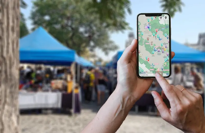 specify what items from THE map should be made visible to the eventgoers. The resulting public event map can be integrated to the event's web site and access from desktops prior to the event, or from phones while at the event. It can also be included as an external link in most festival app software , although another option is to altogether replace your often expensive and cumbersome apps with EventMapStudio. The public event map is responsive/phone friendly, and allows users to select what items they are interested in. Event organizers can include categories such a stage, beer, first aid, food,etc.. These categories can be used to filter items on the event map. The event map also offers geolocation so the user can see their current location with respect to the item they are looking for. Each item also has a popup window associated to it in order to display any useful information.
3D map
Eventmapstudio provides event producers with a 3D event map to better understand the layout and spatial relationships between layout items.
The one source of truth
The power of EventMapStudio is that all these maps are generated from the same data. Running a music festival on the banks of a river that is running high? Need to move some tents at the last minutes? If you move the tent on THE map, the public will automatically see the resulting change on the public map.
So.....looking for an interactive event map? Chances are EventMapStudio has the type of map you are looking for. Register for the free trial.
FAQ on Interactive Event Maps
What is an interactive event map?
An interactive event map is a digital map of your event that different users can explore and interact with. Unlike a static PDF or image, an interactive event map can be filtered by category, updated in real time, and accessed on any device. It can serve multiple audiences simultaneously — attendees navigating the event, vendors finding their location, and staff managing logistics — all from a single map.
How do I create an interactive festival map?
With EventMapStudio you build your festival layout once on a real map, and the interactive festival map is generated automatically from that same data. There is no separate build process, no third party vendor, and no waiting. Any change you make to your master layout is instantly reflected in the map your attendees see.
Can attendees access the interactive event map on their phone?
Yes. The public-facing event map is fully mobile-friendly and geo-enabled, meaning attendees can see their current location relative to stages, food vendors, toilets, parking, and any other items you choose to display. It can be accessed directly from your event website or shared as a link.
Can I create an interactive event map for free?
Yes — EventMapStudio offers a free trial that gives you full access to the interactive event map features. No credit card required. You can build your event layout, generate your interactive map, and share it with attendees before committing to a paid plan.
How do I keep my interactive event map up to date?
Because all maps in EventMapStudio are generated from a single master layout, any update you make is instantly visible everywhere. Move a tent, add a stage, change a vendor location — your attendees, vendors, and staff all see the change in real time without any additional steps.
Can I show different information to different users on my event map?
Yes — this is one of EventMapStudio's core strengths. You control exactly which items are visible on the public-facing map. Backstage areas, staff parking, and artist trailers can remain private while attendees see only the relevant public information. You can also generate filtered maps for specific stakeholders like vendors or security.
Can I embed an interactive event map on my event website?
Yes. The interactive event map generated by EventMapStudio can be embedded directly into your event website, shared as a standalone link, or included in most festival app platforms. Attendees can access it from a desktop before the event and from their phone while on site.
What is the difference between an interactive event map and a festival app?
A festival app is a full mobile application that requires significant investment to build, maintain, and update — and any last minute changes to your layout require going back to the app developer. An interactive event map built with EventMapStudio is generated automatically from your master layout, costs a fraction of the price, and updates instantly. For most festivals and outdoor events, it replaces the need for a dedicated app entirely. It is cheaper, easier to build, and easier to maintain.
Blog comments